
Off the Beaten Path: Bear Rock & Millers Pond
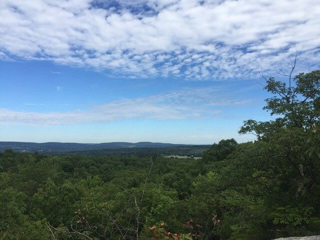
Millers Pond is a popular spot for hiking and swimming. The lot fills up early in the summer and there is no overflow parking. You might even find crowds there this spring. Fear not, there is another way! Lace up your hiking boots and enjoy a lesser-known stretch of the Mattabesett Trail. This hike is 4 miles roundtrip and includes scenic views at Bear Rock (pictured above) and Millers Pond. Shorter and longer options are offered. The trail gains about 70 feet in elevation and is hilly with some rocky sections. It features rock formations, scenic views, mixed forest and a pond.
Hike Overview
Total length: 4 miles with longer and shorter options
Difficulty: Easy to moderate
Type: Out-and-back
Elevation gain: 70 feet
Trail: Blue-blazed Mattabesett Trail
GPS link to trailhead at Harvey Road, Durham

Directions:
From the North: Go south on Rt. 17 though central Durham. At the south end of Durham bear left onto Rt. 79. Almost immediately after bearing left onto Rt. 79, take your first left onto Higganum Rd. Follow Higganum Rd. for 1.3 miles to the first stop sign. Turn right to stay on Higganum Rd. Almost immediately turn left onto Harvey Rd. Drive about 1/2 mile to the where the blue trail crosses the road. There is a pull out (with a small map kiosk) for 2 cars just beyond on the right and plenty of room for cars at the side of the road. Harvey Road ends about a 1/2 mile beyond the parking area.
From the South: Take Rt. 79 north almost to the first Stoplight in Durham. Just before this light turn right onto Higganum Rd. Follow Higganum Rd. for 1.3 miles to the first stop sign. Turn right to stay on Higganum Rd. Almost immediately turn left onto Harvey Rd. Drive about 1/2 mile to the where the blue trail crosses the road. There is a pull out (with a small map kiosk) for 2 cars just beyond on the right and plenty of room for cars at the side of the road. Harvey Road ends about a 1/2 mile beyond the parking area.
The trailhead for this hike is on Harvey Road in Durham, about a half mile from the intersection of Higganum Road. Find the trailhead on the left side of Harvey Road, and a marked pull-off with a map kiosk for parking on the right-hand side.

Begin the hike by heading northbound on the blue-blazed Mattabesset Trail which starts across the road from the parking area diagonally across the street before the parking spot. Pass through mountain laurel groves, and if it’s early spring, listen for frogs at the hidden vernal pools.

After hiking 0.6 miles you’ll come to a junction at Bear Rock. Veer left if you’d like a very steep, but very short scramble to the top of the rock. Veer right for the easier path to views at the top of Bear Rock. If you’d like a 1.2 mile roundtrip hike, you can make this your final destination and head back to the car.

Or continue northward on the blue-blazed trail for the full hike. You will hike near cliffs, interesting rock formations and a variety of different forest ecosystems. In another 1.3 miles you’ll reach the south end of Millers Pond. Enjoy the view of the calm water and relax on the grass, if it isn’t crowded. Head back to the car to complete the 4 mile trip. Or, add a circuit hike around the pond, which is an additional 1.3 miles.

Other Options
Alternate trailhead: If you can’t find parking on Harvey Road or want a slightly longer hike, park on Higganum Road instead of Harvey Road. The would be a 4.6 mile trip. From Higganum Road, hike northbound on the blue-blazed Mattabesset Trail, towards Harvey Road, which you will cross after 0.3 miles hiking. There are some interesting rock features on this brief stretch.
Loop options: Reference the map to create your own variations and loops. For those experienced with navigation, you can return from Millers Pond via the red trail. Where the red trail crosses an overgrown dirt road, look to your right and you’ll see pavement about 100 yards away. That is Harvey Road. (Note, this is an unmarked intersection, and the dirt extension of Harvey Road is not fully indicated on the state map.) Turn right and walk about a half mile down the road to return to your car.
Interested in discovering your own off the beaten path hikes? The Connecticut Walk Book and interactive trail map at ctwoodlands.org are excellent resources.
Coronavirus & Tick Safety
- When social distancing is in effect, give other hikers six feet of space. Do not touch other’s dogs and keep your own dogs on a leash. When stepping off trail to make room, be mindful of any flora underfoot and step on rocks where possible.
- To prevent overcrowding and facilitate social distancing, hike during less popular times such as early mornings and weekdays. Even hiking in a rain jacket during light rain can be a rewarding experience.
- Follow the Leave No Trace principles which have been updated for COVID-19. The document at the link offers important considerations, such as being prepared to use the bathroom outdoors and carrying out your own trash.
- Ticks are active March to November. Wear long clothing, tuck pants into socks, wear a repellant on your skin and pretreat your hiking clothes with permethrin. Shower afterwards and launder clothing. Click here for information on identification of different ticks.
Contributed by Amanda Kenyon and Lucy Meigs.


I was so happy to discover your blog! I tried this hike on 1/17/21 — with our recent spate of mild January weather it was very do-able. Your GPS and written description for the trailhead and parking were spot-on. Bear Rock was impressive. As luck and topography would have it I managed to witness two sunrises! One from the ridge overlook just beyond Bear Rock and another from the shore of Millers Pond. It was such a nice morning I went around the Pond as an added loop like you suggested. I saw a few other hikers as the morning wore on but no crowds. Thanks for doing these blog posts. One other comment — your elevation gain says 70′ — my Garmin registered 464′ overall and there wouldn’t have been much for the pond loop. I’m wondering if that was meant to be just to the top of Bear Rock?