
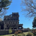
Off the Beaten Path: Nayantaquit Trail
Nestled in the 5,062-acre Nehantic State Forest in Lyme, the Nayantaquit Trail is one of Connecticut’s Blue-blazed hiking trails. The Nayantaquit Trail meanders through a dense, hardwood forest and allows hikers to experience rocky ups and downs, thriving flora, and rock formations. In addition, this hike allows you to see one of Rockfall’s 2021 Environmental Grants in action! Don’t underestimate this trail – it is a workout! Be sure to wear appropriate hiking shoes, long pants (many parts of the trail are overgrown), and bring plenty of water.
Hike Overview
Total length: 4.2 miles (Shorter and longer options available)
Difficulty: Moderate to difficult
Type: Loop
Elevation change: 653 feet
Trail: Blue-blazed Nayantaquit Trail
Dog Policy: Keep your dogs on-leash and under control at all times.
Download the trail map from CT-DEEP here. There is not a map on-site.

GPS link to trailhead on Keeney Road in Lyme
Be aware that the trail is accessed via dirt road.
Directions: From CT-9 S, merge onto I-95 N/US-1 N toward New London/Providence. Take exit 70 for US-1/CT-156 toward Old Lyme. Use the left lane to keep left at the fork, and follow signs for the Florence Griswold Museum/Lyme Academy of Fine Arts. Continue on CT-156 W/US-1 N. Turn right onto Beaver Brook Road, and then right onto Keeny Road. The parking lot for the Nayantaquit Trail will be on your right about 1.3 miles down the Keeny Road.
This is one of multiple parking lots for the Nehantic State Forest, but it is the only one that provides direct access to the Nayantaquit Trail. The lot is spacious and provides room for plenty of cars.
To start your hike, go through the gate circled in red and head to your left, where you’ll see a sign signifying the start of the trail.

The trailhead sign shows the blue trail markers and indicates that this is an official CT Forest & Park Blue Blazed Hiking Trail. There are over 825 miles of Blue Blazed Hiking Trails in Connecticut, maintained by the Connecticut Forest & Park Association. For more information, see here. To follow along the route for this Blue Blazed Hiking Trail, head up the path behind the trailhead sign.


Follow the trail through the forest and between the stone wall. While this particular landmark is manmade, this is the first taste of many rock formations throughout the hike.


Shortly past the stone wall, you’ll come across this glacial erratic known as Chipmunk Boulder. A glacial erratic is a large boulder that has been transported by ice and deposited elsewhere – typically, these rocks differ in characteristics from of native rocks of where they are deposited. To learn more about glacial erratics, check out Part 2 of Wesleyan Professor Dana Royer’s guest blog “Middletown 20,000 Years Ago & Its Enduring Legacy” here.

As you continue along the blue trail, you’ll walk through and over various other rock formations – this continues throughout the length of the trail, so be sure to wear appropriate shoes!


Walking straight on the path, you’ll come to a fork in the road – I neglected to get a proper picture, but you’ll see the blue blazes circled on the left and the trail sign on the tree, circled on the right. When you reach this point, veer left to hike the loop clockwise. The trail will loop back to this spot on your way back.

You’ll shortly come across a sign:
“New Forest Begins: Mature forests are harvested to provide an opportunity for hardwood seedlings to grow. Foresters call this a Regeneration Harvest. In 10 years, this area will be occupied by a dense stand of trees 15 to 20 feet tall. Regeneration harvests are continuously being made so that our State Forests will eventually have a healthy balance of trees in all age classes. Older forests are more vulnerable to damage caused by catastrophic hurricanes and insect and disease infestation. A balance of forest age classes will minimize the impact of damaging agents in our forests as well as provide necessary habitat diversity for wildlife.”

According to CT DEEP, the Native Americans inhabiting the area prior to European settlement routinely burned sections of the forest in order to make the forest more habitable. This practice allowed grasses and berries to grow that attracted even more wildlife to the area, including game animals. In addition, the burns remove the dense understory, allowing more light to the forest floor to promote growth. DEEP continues the practice of Regeneration Harvests today, with a 17-acre burn happening as recently as May 2021.

Go past the sign and continue down the trail.

When you reach them, walk through the two boulders – marked with blue blazes – to start traversing a series of fun rock formations. The trail itself goes around and through the rocks, but sometimes it’s more fun to climb. Kids will love this section!


Just past the rock formations is a small stream – this is one of a few small bodies of water found on the trail.

Past the stream, you’ll hit one of the steep sections of trail – I wasn’t kidding, while 653 feet of elevation gain might not seem like much this trail was a workout, especially in the heat! You’ll thank yourself for having a water bottle handy.


Once you’ve made it up the hill, you’re rewarded with another, slightly larger stream with a footbridge – who doesn’t love a footbridge?! Cross the bridge and it will lead you through a beautiful fern-lined pathway.


Keep traveling on the blue-blazed trail. Eventually, you’ll come to a crossroads of the Nayantaquit Trail and the Crossroads Trail. If you’d like a shorter hike, this is a perfect place to head back to your car. This .6 mile trail will take you to the other side of the loop, where you can reconnect with this hike. If you take a look at the trail map, you’ll see that taking this trail will cut a significant portion of the loop, which is perfect if you’re short on time or not feeling up to a longer hike.

Hang left, and continue hiking on the Nayantaquit Trail.

Shortly after the sign for the Crossover Trail, you’ll stumble upon another intersection. If you’d like to add some miles to your hike (an additional 3 miles there and back) and get some great water views, take the left on the Uncas Pond Connector trail and check out Uncas Pond as seen on the map. Our route continues on the – you guessed it – Nayantaquit Trail. Take a right and head through another patch of ferns.


At the fork in the road, follow the blue arrow and keep right on the path.


For a brief section, the trail overlaps with the Valley Road forest road, as shown on the trail map. Take a right, as indicated by the blazes. Once you walk a bit, you’ll find a porta-potty – in case nature calls while you’re on the trails!


As you keep walking, you’ll come across two forks in the road – keep left on both of them. The second fork will put you back onto the Nayantaquit Trail exclusively (note the blue blazes in the second image), where you’ll begin your ascent up Nickerson Hill.


Boulders – glacial erratic boulders, as we learned before – mark the summit of Nickerson Hill, the highest point on the Nayantaquit Trail at 425 ft. When we reached the top, we were met with dense treetops and cloudy skies. On a clearer day in the fall or winter, you would be able to see a view of the Long Island Sound from this point – standing on a boulder helps!


The summit is a great spot to stop for a short break or a snack. Once you’re ready to continue your hike, pick up the trail to the left.


Continue making your way down Nickerson Hill. The trail will veer right – as indicated on the trail map and the blue CFPA blaze pictured – which will put you on the last leg of the loop, headed back towards your car.

As you continue down the trail you’ll make your way over two more footbridges and small bodies of water. In addition, you’ll pass the second access point to the Crossover Trail – if you chose to shorten your hike earlier, this is where you’ll pick up with our route. Walk straight past the Crossover Trail sign to stay on the Nayantaquit Trail.
Keep walking – as far as footbridges go, you haven’t seen anything yet!


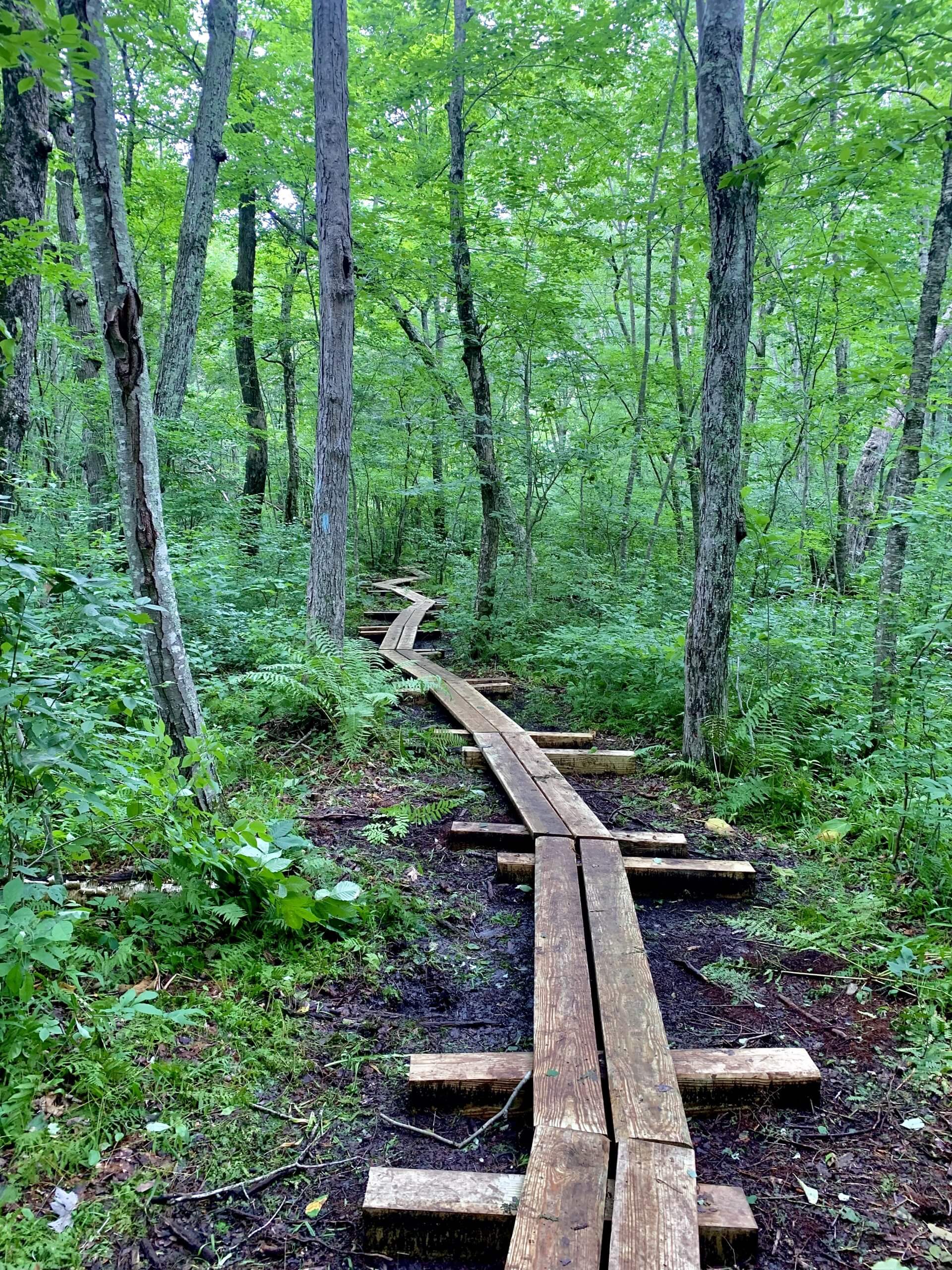
You’ll soon come across the next footbridge, which you’ll notice looks a bit different from the rest!
This summer, the Connecticut Forest & Park Association installed a series of bog bridges on the trail, a project that was funded in part by a 2021 Environmental Grant from The Rockfall Foundation.
Spanning over 180 feet, these bridges protect the forest ecosystem – during the spring and summer, the trail is braided as hikers try to avoid the muddiest areas. The bridges help keep hikers on-trail and avoid disrupting the native flora & fauna. With an increase in hikers nationwide due to the Covid-19 pandemic, the installation of these bridges was increasingly urgent in order to protect the forest.


In addition to our Nayantaquit Trail hike, Rockfall staff paid special a visit to the bog bridges, accompanied by staff from the Connecticut Forest & Park Association. Pictured here are Claire Cain, CFPA Trails Director, Tony Marino, Executive Director at The Rockfall Foundation, and James Little, CFPA Development Director.

To learn more about the work of the Connecticut Forest & Park Association, check out their website here.
To learn more about Rockfall’s grant awards and how to apply for a 2022 Environmental Grant, see here.

If you won’t be able to make it to the trail (or just want to check it out before your trip), watch a full walkthrough of the bog-bridges on our Youtube Channel.
Back finish to our hike! Once you’ve covered the bog bridges, you’ll be on your way back to your car. You’ll meet up again with the intersection from the beginning, marked by the blue blaze and the Nayantaquit Trail sign. Take a left and follow the trail back to the original gate and parking lot.

With all of the rain we’ve gotten this summer, the Nehantic State Forest is full of thriving plants and fungi. Check out some of our findings from throughout the hike – if you do the loop yourself, share in the comments what you found on your trip!


Alternative Options
- For a shorter hike, utilize the Crossroads Trail as seen on the map. This trail is a little over ~.6 miles long, and cuts out a significant portion of the loop.
- For a longer hike, check out the blue/green blazed Uncas Pond Connector Trail as seen on the map. As an out and back addition, this adds a little over 3 miles to your hike.
Interested in discovering your own off the beaten path hikes? The Connecticut Walk Book and interactive maps on www.ctwoodlands.org are excellent resources.
Other Considerations:
- Ticks are active March to November, and this is an especially bad year for ticks. Wear long clothing, tuck pants into socks, wear a repellant on your skin and pretreat your hiking clothes with permethrin. Shower afterwards and launder clothing. Click here for information on identification of different ticks.
- Follow the Leave No Trace The document at the link offers important considerations, such as being prepared to use the bathroom outdoors and carrying out your own trash.
- Follow Covid-19 safety precautions as comfortable. If unvaccinated, we recommend bringing a mask in your bag in the event you run into other hikers.
Contributed by Liz Britney


